Drainage Related Terms
culvert – a pipe that runs under an obstruction, such as a driveway or walkway. Originally, all driveway culverts in the community were installed as individual properties were developed
ditch – a long, narrow channel dug into the ground, usually along roads or fields, used for drainage or irrigation. A ditch is generally designed to hold water until it can percolate, evaporate, or disappear by other natural methods. Removing all vegetation from the bottom of ditches allows for more efficient movement of water between the ditch and the ground. It is also necessary to keep the bottoms clear of debris for this same reason.
swale – a shallow, gently sloped depression in the land designed to slow, capture, and redirect stormwater runoff. These are designed more for transport of water than temporary storage of water.
We use the terms interchangeably, because our drainage system, while designed to move water in a generally downhill direction, also by necessity has to store storm water for a period of time because the amount of “downhill” beyond our community is severely limited.
Because most properties on each individual pine side street were originally owned by the same families, each street has its own variations in the designs of the original swales and culverts. Original ones were constructed of 4′ long concrete sections that had one flared end so multiple sections could be placed together. Generally, 5 of these were installed under most original driveways. As these sections shifted positions over the years, gaps formed, sand fell into the pipe, roots grew into the gaps, and eventually many of these culverts became completely clogged. Probably in the 1980’s, galvanized corrugated steel was used for many driveway culverts. These have a limited lifespan of about 20 years, and most in the community are well past that age. Most new pipes installed since 2000 are black plastic (HDPE-high density polyethelene), which is supposed to last for a century.
In most of the community, the original ditches were rather shallow. Previous work has made them wider (because the increased cross sectional area means they can hold more water) and deeper (so that they can help remove more ground water). In order for our ditches to be able to efficiently remove ground water from the adjacent areas, the ditch sides need to be kept clear of all vegetation. This includes not only vegetation growing inside the ditches, but other material that accumulates in the bottoms. (Click HERE for several handouts that were circulated to the community in the 2020-23 time frame explaining this in more detail.)
Internal Drainage Maintenance (updated 6/25/26):
In the spring of 2024, MBA contracted with Harry Caswell Plumbing to blow/vacuum debris out of every single driveway culvert and other underground piping in the community. In December 2025, the Community Facilities Committee checked all the driveway culverts, and noted a few along Errett and Short that are located below the level of the swale and thus collect some debris, but nothing too alarming.
In addition to this bi-annual work, our landscaping company routinely cuts anything growing in the swales and removes all debris several times a year. This work is generally done by hand or with small hand tools; after any particular ditch is reengineered, it should NOT be necessary for heavy equipment to be able to access the site.
Internal Drainage Improvements (updated 6/25/26):
While the above-noted 2024 Caswell original work cleared debris from many portions of the drainage system, it also revealed some rusting steel culverts. While some are scattered throughout the community, most of these are along Evergreen Road. The issues with various retaining walls on the sides of various driveways and the fact that the swale is deeper make this project more complex than any other street. Click HERE for further information, which admittedly is rather bare-bones at this time. As plans develop further, we will share the details with the affected properties.
External Drainage (updated 6/25/26):
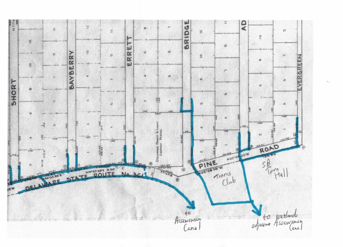
In 2022-24, DNREC took elevation surveys along Kent Ave, Pine Path and the western end of Evergreen Rd in an attempt to find a way to rework the drainage system between us and the Assawoman Canal. Due to the incredible number of buried utilities (in addition to standard sewer and water pipes and electric and communications cables, there is a 30″ sewer main that runs out into the ocean and several high voltage electric lines that connect the 2 substations), they were unable to come up with a plan that was economically justifiable and didn’t involve a pumping station, which someone would have to maintain (all such pumps along DelDOT roadways are actually in towns and are maintained by the respective municipal departments).
When we last met onsite (September 2025), we suggested that they try to address the rusting and collapsing pipe beyond the west end of Bridge Rd, and they seemed amenable. This was good news for several reasons:1) the pipe runs under both MBA and Tennis Club property (joint construction projects are always fun), 2) the pipe runs over and under an incredible number of Verizon and other communication lines (MBA is NOT going to undertake something that complex), 3) this is one of the most critical pieces of our drainage infrastructure, and it is failing at this time. While the plan (we haven’t seen it yet, but it was described to us) involves the swale in front of the Tennis Club, our contact wasn’t sure how far that might extend. However bonus reason 4) is “easements for the project would be required for FAR FEWER entities”. As of this spring, our contact at DNREC had moved on to the Sussex Conservation District.
There is currently a 15″ diameter culvert under Kent Ave which carries storm water from Short, Bayberry and Errett Roads towards the canal; this pipe is currently free flowing, so the water level in the ditches on both sides of Kent Ave are generally equal. We have been advised that DelDOT will not replace this pipe with a larger diameter one because downstream conditions cannot be altered to accept more water than is currently the case. We plan to install elevation markers on both sides of the road so it should be quite apparent if the culvert under Kent Ave gets clogged.
Drainage Related Links
- Current Middlesex Beach Drainage Schematic
- Sussex Conservation Stormwater information
- Homeowner’s guide to Stormwater management
- Past Sussex Conservation District presentations
- Bethany Beach Stormwater and Flooding Committee Information
- Fight Flooding Brochure (from Town of Bethany Beach)
- South Bethany Resiliency Committee Information
- South Bethany Resiliency Implementation Plan
- Jefferson Creek Tide Data
- Lewes Storm Surge Info
- OC Inlet Storm Surge Info
- US Storm Surge Info
- Millsboro Pond Flow Data
- Tax Ditches in Delaware